Saturday, June 23, 2012

Leaving El Paso


Five days until I leave El Paso.

My family is gone, the house is empty and I have no reason to return to it.  I have no reason (unless I find one) to return to the west side of the city.  I have no practical reason to do anything except stay my hotel room, eat and go to work.  Nothing else.

I don’t have many friends, and fewer friends here.  After three and half years, those I would call friends have moved away.  Other friends are not really friends, not so much when they figure personal errands are more important than sharing final moments with you before you leave.  I really don’t blame them.  I’m no different.  Friends I’ve had whose company I enjoyed at work I never made time for outside of work. 

Nor they for me.

When you are younger your interaction with friends is more unplanned, more casual.  Stopping by was acceptable, so was overstaying your welcome.  With age you become more guarded, more inconvenienced by casual interaction with friends.  Less time on the telephone.  Emails become fewer and fewer.  It takes dedication, maintenance to build and maintain strong relationships with your friends and acquaintances.   Being part of a transient lifestyle, moving every so often, compounds the difficulty of forming bonds with others around you.  

Now I’m beginning again.

After three and half years, the place you call home grows on you in profound ways.  El Paso, a border city home to mostly Mexican-Americans and Mexicans, is a unique culture that outsiders do not easily adjust to.  Time allows you to adapt, or if not adapt, accept.  I accepted El Paso, Mexican Food, hot, arid weather, no rain, long drives, inconsiderate and dangerous drivers, Spanish spoken rather than English, Mexican license plates, the Juarez Mayor living in our neighborhood while his constituents live in fear, Spanish-speaking only classes in my daughter's public school, dust storms, roadside views of one of the poorest, most violent cities in the world during my morning and evening commutes, the worst music selection on the radio, and being one of only a few households that does their own yard work and housecleaning.  I will not miss the fact every asshole in this city has a dog in their yard and has house parties until three in the morning and no one has the balls to tell them to be quiet or call the police.

West Texas (far West Texas) has been my home for three and half years.  I wear boots and jeans year-round.  I wear long-sleeve shirts year round.  The heat no longer bothers me.  I don’t know what I’ll do in two weeks when I’m outside of Kansas City near the Missouri River and the humidity is ten times as intense.  I may not change anything.  I’m 41, and I’m concerned less and less about my comfort.  My comfort becomes important only when I am unable to do what I normally do, and If not, I change what needs to be changed.

I will miss El Paso, but I leave with no regrets about anything I’ve left behind.  Every time I move away from somewhere, I first feel the need to take in as much as I can of the things I have enjoyed most about a place.  Later when the time of departure nears, that desire lessens and though you don’t acknowledge it, you’ve already left where you are.  The emotions are gone and you just want to get gone and on your way.

Things I despise about this town are the things that collectively lead me to admire it.  My favorite, iconic scene in the city – driving I-10 eastbound near Schuster Avenue Exit 18.  To the left of the highway – Unversity of Texas – El Paso, with its Sun Bowl and Pagoda, Aztec Temple-like university buildings; on the right – the disinegrating remains of the McKinney Wrecking Company, the Jesus Lives grain bins of an unnamed rescue mission, the border fence, the Rio Grande, then the crumbling hillsides of the Northwest Juarez outskirts, with their hovels of all different colors clinging to the precipice, not one the same as another, with steep, unfinished streets leading up and across the undulating terrain, with Mount Cristo Rey to the North, the Asarco smelter smokestack standing like a sentinel shoulder to shoulder with Mount Cristo Rey’s statue of Jesus Christ, creating an enigmatic scene of a struggling civilization so close to their dream of a better life, within arm’s reach of it, but truly a world away, a scene of layers of ascension – a dirty drug and murder-ridden purgatory, separated by a river and a fence with sentries posted to prevent any further journey along the path to self-determination, with a sea of automobiles of those chosen for that life looking down upon them in contempt, disregard.  Cutting through all, the Burlington Northern-Santa Fe passes between Jesus Christ and the smokestacks, then between I-10 and the rescue mission.

Few places offer this experience of extremes…and at a safe distance.

Though I have many dislikes, this contrast of contrasts is moving.   No artist could contrive a more chaotic, perfect scene.

What if a community was rid of these extremes?  If everything was good?  How would it be?  I would not think much is left to the imagination.  No bad to measure the good, no good to measure the bad.

If your city, if your life - were a painting, would anyone find it the least bit fascinating?

Continuing down I-10 the morning sun casts a shadow across the Franklin Mountains, the rail yards down town, the historic district with its bungalows, the refinery structures and oil tanks in central El Paso north of the river, the consistent sprawl of Cuidad Juarez endlessly to south, until Highway 54 comes into view and the Spanish-style buildings and steeple on West Fort Bliss sit atop a mesa to the northeast.  These are the scenes from my daily life in El Paso that will remain with me as common memories of a place I grew to accept and appreciate. 

My favorite stores – Starr Westernwear and the Tony Lama boot outlets – unique to El Paso.  Authenticity of any kind is becoming more and more of a rarity in the world.

So now I’ll leave my office and return to my hotel room, eat dinner, read, watch television.   In five days I’ll wake up and I’ll no longer be here.  The people and places I see every day will be gone.  Most of these people and places I’ll never see again, or see them the way I do now.   Will life continue on here, I will not know, because I will not be here, and therefore I cannot assume it does as I remember it. 

Our existence in our life and in the lives of others is only in our presence at a place and time and no other.  Your life only exists where you are and with the people you are with and nowhere else and with no one else.

This part of my life is ending, gone.

Sunday, May 13, 2012

Winter-Spring 2012: Organ Needle, Guadalupe Peak, South Franklin Mountain, and Cookes Peak

Though I write primarily about longer experiences, there are many shorter outings that never get the attention they deserve.  As Memorial Day weekend nears, and as we finalize our plans to head to the Pecos Wilderness and climb Truchas Peak, it's worthwhile to share some of the photos from these outings.  January 22nd, the three of us attempted to climb Organ Needle, the highest point in the Organ Mountains, a range that creates a magnificent skyline to the east of Las Cruces, New Mexico.  In mid-February we traveled to Guadalupe Mountains National Park, where we backpacked to the summit of Guadalupe Peak, the highest point in Texas.  We camped overnight a mile below the summit and returned the next day.    One weekend afternoon in March Alex and I climbed to the summit of South Franklin Mountain, the large rocky top mountain that is the centerpiece of El Paso, Texas, which has a steep, rugged 1.5 mile route to a grouping of radio towers at its highest point.  Finally, in late April, the three of us traveled north of Deming and climbed Cookes Peak, an isolated mountain in ranch country that has an incredible rock dome summit, with a rugged, two-mile approach.  The following photos are my favorites from each of these remarkable places.


Organ Needle

Early morning, initial approach to Organ Mountains.
Alex and Monica near Grey Eminence, Organ Needle.


Alex and Monica approaching Yellow Rock.  Grey Eminence is the dark rock above, with Organ Needle in the high background.

Looking back down towards La Cueva, the fin-like rock formation in the valley below.
Organ Needle.

Monica and Alex descend the route near Grey Eminence.

 Guadalupe Peak

About a mile up the trail on the four mile climb to Guadalupe Peak.  It is about 40 F and windy.

Sunrise on the summit of Guadalupe Peak, as seen from our backcountry campsite.

Our campsite.  It was in the 20s and very windy overnight.

Alex filling out the summit register on top of Guadalupe Peak.

El Capitan and to the south from the summit.

Sunset, looking east, from backcountry campsite.

Sunrise.

 South Franklin Mountain

Alex on top of South Franklin Mountain.

Looking south from summit towards Ranger Peak and the mountains south of Juarez, Mexico.
Looking north towards North Franklin Mountain, the highest in the range.

Looking west towards the Elephant's Trunk and the West Side of El Paso.

Cookes Peak

Cookes Peak.

Cookes Peak.
Monica atop the draw on approach to Cookes Peak summit.

Monica and Alex begin the Class 2+ scramble to the south summit.
Climbing the south summit.

Climbing the south summit.
Monica and Alex reach top of Cookes Peak main summit.

Alex filling out summit register.
Monica and Alex prepare lunch.
Nap time.

Nap time.
Ted on summit of Cookes Peak.

Sunday, March 18, 2012

Black Canyon, Aldo Leopold Wilderness, March 13-16, 2012

Sunrise, Black Canyon above Falls Canyon, March 15, 2012.

Leaving the car, we briefly walked along a wooded slope before descending downhill; crossing underneath an old stock fence wire, then came to the base of the hill, meeting up with the south bank of the creek.  The creek flows steadily eastward, with short, steep banks and filled with small round boulders.  A few hundred yards to the north stood a homestead on an open, grassy slope, a red structure, with smaller outbuildings and a stable, also painted red.  The path continued along the south side of the creek, coming to a small gate, open, with a USFS sign on the far side, indicating that one was crossing onto private land coming from the other direction.

After crossing through the gate, we continued along the path.  We were warm, with the sun out, and the end of winter.  In the shade of the north-facing slopes there were sections of trail still covered in ice.  On the slope above the homestead, a dog begins barking.  Shortly after, we see the dog, which is bounding down the slope towards the open flat flood plain of the creek.  The flood plain changes between grass-covered areas and stands of cottonwood, still without their leaves.  Behind him, a woman in a fluorescent green pullover follows him towards us.

Black Canyon Ranch homestead, NM.

She raises her arm and calls out to us, but I can’t understand her.  I wave back and move off the trail and stop by the fence.  I tell Alex to hold up.

Trail’s closed.
I’m sorry, I can’t hear you. Say again?
Trail’s closed.

The woman continues to walk across the thick, dead grass, lying flat in a random pattern, only weeks before covered under the weight of the snow, which now fills the creek as it continues on its path towards the East Fork of the Gila River, several miles to the west.  She continues to walk with the dog, but their direction of travel turns slightly east, and it becomes evident she has no intention on meeting me face to face.

The trail is closed.
Can you tell us the right way to go?
Trail’s closed.

I do not know what to do.  I did not know the history of this place, and how I came to find myself in this situation.  I did not know that once the woman approached me I was not on her property, but in fact on federal land.  I did not know that between crossing beneath the wire and passing through the small gate south of the creek I was on private property.  Confused by the circumstances, we returned to the private property side of the gate, failing to realize that we could have simply continued on the path and ignored the woman; however, her approach had the desired effect.  25 miles from Highway 35 along Route 150, a dirt road that travels north to south over 50 miles through the deep ravines and across the ridgelines of the forest spanning the gap between the Gila and Aldo Leopold Wilderness areas, and another mile off of Route 150 we found ourselves near one of the few remaining private landholdings in the entire forest.  In the moment, it made more sense to show ourselves differential to her rather than continue the confrontation.

Behind the gate, a steep route between the rocks leads up the hillside to the south of the creek.  We could follow this over and continue along the hillside, past the eastern end of the homestead and stock fence and rejoin the trail and continue our movement.  In the distance to the northeast, I could make out the depression between mountains, where Diamond Bar Creek met with Black Canyon.  As we moved closer to the junction of the two streams, we would begin our descent towards the river bottom.

Loaded down with gear and stepping through patches of ice, the climb up the hillside was slow.  Uncertainty about the situation was evident in my voice, identified by Alex, who begins to indicate her insecurity.  Once at the top of the steep chute, we traverse an ice-covered section of a game trail we are attempting to follow to higher ground.  The hillside is steep enough that it is difficult to find a place to set my rucksack without it tumbling to the creek bottom.  With Alex across the ice, she is visibility shaken by complexity of the completed task, and sits down to collect herself.  I move further up the hillside, and continue to search for a reliable game trail that will allow us to traverse to the far side of the mountain and re-connect with the trail.  I find a well-defined game trail, with ice-covered sections, then return to find Alex.

Alex, tense and looking at me as if she was waiting for me to provide her reassurance that our plans were not completely in jeopardy, and if the next four days would be like the last thirty minutes, put on her pack and prepared for what was next.  The hillside, covered with small ponderosa, was dispersed with cat claw, which tore at our arms and legs as we worked our way to the west.  The game trail initially presented some challenges, Alex and I having to cross several more iced-over segments, slowing our progress.  We reach a level clearing that is free of snow and ice, and looking across the flood plain, I realize we are directly south of the Diamond Bar Canyon confluence, and begin descending the hillside.  Two hours after leaving our car, Alex and I find the original trail, relieved, and continue up Black Canyon.

The encounter leaves a bitter taste in my mouth.  The detour, covering only a mile of our original route, takes two hours to complete.  That afternoon we complete six miles, crossing the stream twelve times.  We come across a deep pool in the creek and see several large trout swimming back and forth, dammed by rocks twenty five feet apart.  We set up camp here, in a dry area a few feet from the north-facing slope, covered in snow.  Two hours earlier, as we break on a fallen log next to the trail, three cow elk slowly make their way west along the creek, each one taking turns on watch while the other two lower their heads to drink water.  After ten minutes, the elk close the distance between us and one takes notice of us, then the three turn west and gallop up the north hillside.  The camp, like most areas along the stream, is riddled with deep elk tracks, muddied by the melting snow.

After setting up the tent, we dig a fire pit and collect rocks for the ring.  Not much wind and the area, like most we pass through the following three days, is a combination of burn areas, fallen trees, and snow, along with large and small ponderosa, then Douglas fir and spruce as we gain elevation.  Alex and I collect fire wood, eat dinner and start a fire.  The fires become a novelty in the evening and a necessity in the mornings.  Mornings were cold, well below freezing, and without sun until seven-thirty.  We spend nearly as much time in the tent each evening as we do outside throughout the week.  Alex alternates between her river shoes and hiking shoes each day, while I continue to wear my wet shoes.  The following morning, with my socks frozen and boots frozen, I leave myself no choice but to force my bare feet into my frozen shoes.  I start the morning fire and lay my socks on the adjacent stones, along with socks of Alex, before I make her put them back on.  We make breakfast and proceed to breaking camp.  Today we must cover at least eight and a half miles if we intend to reach the summit of Reeds Peak and spend the night in the abandoned lookout cabin.  Three days later we meet a gentleman who claims to have manned the lookout in the summer of 1958.

Alex is shaken by the morning cold, wearing wet socks and crossing the stream repeatedly though it has not warmed up outside above forty degrees.  Eventually the sun covers the route, and we warm up enough to withstand the snow melt water.  My camelbak hose frozen, I resort to long stretches of the walk without water and drink during breaks.  After multiple stream crossings we reach a wider area of the creek bottom, believing it the saddle above Black Canyon Box, a narrow portion of Black Canyon with high stone walls and a series of pools and cascades.  With no trail juncture in sight a mile following the false saddle, we begin ascending a hillside north of the creek and come to the actual saddle, capped with large boulders and offering a review of the mountains bordering the canyon, but no sign of Reeds Peak, our trajectory blocked by a lower mountaintop, void of live trees, only burned trees, and a snow-covered slope.  Beyond the saddle we continue downhill and rejoin the stream, continuing on to the trail juncture, but never reaching it.  At three o’clock I begin quietly scouting potential camps, considering our elevation is much, much lower than Reeds Peak, making it unconscionable to believe we will make the lookout cabin in time before sunset.  Finally we identify a weathered trail sign, split horizontally with letters barely legible. 

Diamond Peak 8
Reeds Peak 4
(arrow the direction we traveled from) Black Canyon Trail No. 72

What happened? We certainly walked more than six miles, where we expected to reach our intersection to turn southeast and begin the steeper climb the remaining distance to Reeds Peak.  After re-examining the map, we assessed we were in the vicinity of Reeds Meadow, and were possibly at the intersection of trail no. 72 and the Continental Divide Trail.  We traveled several miles beyond our intended turn, though it was not visible to us.  Now three-thirty, the sound of uncertainty returned to my voice and body language, and was quickly identified by Alex, who became shaken by the prospect of more walking.  I explained to her the circumstances, and then re-explained a portion after she assumed I meant we would backtrack over twelve miles the next day.  Instead, we would attempt to walk past the previous night’s camp, so on day four we had only a short distance to complete and focus on negotiating the homestead issue if necessary. 

Alex at the junction with the Continental Divide Trail, March 14, 2012.

We left our packs momentarily and walked over to the large, open meadow we assumed was Reeds Meadow, but rather a meadow further west, which was the source of the creek in Black Canyon, traveling nearly forty miles before converging with the East Fork of the Gila River, but here only an open meadow with the late snow seeping into its bog, creating a series of small pools and slow-moving arteries that would several hundred yards later become a moving stream, and later a canyon river supporting Gila Trout and a multitude of small and large game indigenous to the area, and the large flora, including the cottonwoods, ponderosas, Douglas firs, and spruce amongst others.  Here is where it all begins, much like every large western river, whose volume is contingent upon the winter snowfall, which melts away at winters end and the beginning of spring and moves down the mountainsides through the high mountain canyons, traveling out into the high desert before reaching the large desert valleys with their farming communities and acequias to water cotton, chiles, fruit trees, pecan forests and other means of subsistence throughout the region, closely managed by their communities in a centuries-old system inherited from the old world thousands of miles to the east.

I relayed to Alex that the goals for our tour were changing, and that Reeds Peak would wait for another day.  We could extend our stay an additional day but have no way to relay home the change in plans.  To continue the next day would leave us one half day to cover over nineteen miles of a thirty-four mile circuit and I assessed Alex good for a hard six to eight miles daily carrying a pack.  We descended down to the last known camp location I scouted on our ingress, which sat only one hundred yards pack from the zenith of our route.  We encountered several deep snowdrifts the past few miles, leaving postholes and slowing our progress to a near standstill, and expected much more of this if we continued on to Reeds Peak, inevitably leading to a less than savory overnight situation, likely short of our objective.  The camp was pleasant, a level area beneath the trees covered with needles rather than the thick grasses flattened by snow and pocked by game tracks we encountered in most areas alongside the creek, fifty feet from the fledging beginnings of a stream, no more than three inches deep and filled with aspen leaves and algae, with no shortage of firewood, and kindling readily available with simply sweeping your hand across the forest floor, along with dried grass and a plant with likeness to babies breath, which made for an easy fire.  We made at setting up camp, starting a fire before dinner, it being much colder at a higher elevation than the first evening. Drying my shoes and socks was priority, so I remained barefoot most of the evening, leading to tree sap on my feet along with everything that would stick to it.  After dinner we packed up all of our food and supplies and pulled the rucksack up a tree adjacent to our camp with our bear rope.  I routed out all large fallen tree branches with smaller branches and built a large obstruction beneath the bag to prevent bears and other animals from attempting to climb the tree.  Rather than remove only the food items from my rucksack and hoist in a smaller bag, I chose to raise the entire load, making it difficult to get the bag more than six feet off the ground.  After completing the obstacle around the tree, I went to work collecting more wood to build a fence around the tent to create more stand-off between our small tent and any passing wildlife, not expecting to encounter anything of significance but rather as a precaution.  Another night without incident, with Alex falling asleep after an hour of nervous anticipation of the unknown.

Ted at camp, morning, March 15, 2012.

A much colder morning followed, after another long evening of battling the cold which comes with lying still for very long and moving every two hours or so to accommodate my back pain by switching positions, getting plenty of sleep but not in the long, unbroken periods more common at home.  I start the fire and begin collecting more wood and decide a larger fire is necessary for both of us to prepare for the long day awaiting us, walking eight miles or more before scouting out our final camp.  Slow to leave camp because of the dark mornings and cold temperatures better they be warmer before crossing the snow-fed stream and walking with wet feet, we depart at ten o’clock, continue down Black Canyon for thirty minutes until I realize I left the bear rope hoisted in the tree; we decide whether or not leave it behind or continue, and decide to return back to the camp to retrieve, leaving our packs by the trail.  Alex and I walk for fifteen minutes and I realize this is demoralizing for her, to walk over the same ground a fourth time since yesterday, and believing we are not far, decide to let her rest while I run the remaining distance to the rope, returning in eight minutes, eight minutes too long for a young person to feel secure by themselves, and I find her walking up the trail to meet me, upset by the situation, and I apologize for leaving the rope and leaving her behind to get the rope, and we continue back to our packs.  She is excited about returning to the saddle, where I agree to have lunch and spend some time climbing around on the rocks.  An hour and a half later we arrive at the saddle, eat lunch, and explore the rock outcroppings before continuing on.  We push hard along the trail, but our progress is slow because of the multiple stream crossings, and eventually we pass our camp from two nights before, continuing to walk with the goal of reaching the Aspen Canyon junction, no more than four miles from the beginning of our circuit.

We come down over a hill to an open floodplain and see the trail sign and cairns for Aspen Canyon, across the floodplain in the shadows are two bull elk who see us at the same time, then turn and quickly run across the stream and up the hillside to the south.   We continue into Aspen Canyon to find a camp, and continue for several minutes, only to cross Aspen Canyon Creek, then Black Canyon Creek, and selecting a site at the bottom of the hill we crossed twenty minutes earlier, with Alex slipping and falling in the creek during our last crossing, so we unpack my bag and she changes into a dry set of clothing.  Alex is tired, hiking over eight miles, a personal record for her, and we forgo a cooked meal and eat the rest of our lunch, the best meal we have eaten the entire trip, according to her.  No fire that evening so we can expedite our move back to the car the following morning, and I proceed to prepare my bag for the bear rope and continue through the same routine as the previous evening, building a fence around the bear bag tree and tent.

The next morning, the final morning, we begin early, two hours earlier than the two previous mornings, and it is cold, very cold, and we keep most of our night clothing on, including our winter caps, for the duration of the trek out.  With the cold, I want to avoid getting wet in stream crossings, and spend a considerable amount of time bypassing the stream until we find a location we can cross without getting wet, successful the first four times but eventually surrendering to the reality that at some point it will become unavoidable, so I carry Alex over the remaining crossings, as she is down to her last set of clothing and socks, and I want her to be comfortable during the four hour return trip to El Paso later that day.  We reach the part of the trail we bypassed, and continue forward on the correct trail, only to find it takes us to the same location of our confrontation the first day, and we move quickly and quietly, avoiding the loud crunching of the ice and bypassing in the grass, but eventually the dog takes notice and begins barking, so we begin running until we are around the corner and begin the climb up the final hill, back under the wire to the car.  On the old stock fence are two new private property signs, then at the end of the old two lane road a wire is across, with several pink ribbons and another private property sign, all not there the first day.  The “Forest Trail” sign and supporting pole are missing, and a note is under my wiper blade, written with a black marker in neat female handwriting.

You went thru private property.
Signs are up and pretty clear.
Please take note and do not tresspass again
thanks
Black Canyon Ranch

 I realize that I am probably lucky that something worse did not occur, maybe the towing of my car, which would be a major undertaking considering the proximity to the nearest service station and cost that would be incurred by the property owner, though I was not parked on private property.  Instead of changing clothes by the car, we drive out to Route 150 and enter Lower Black Canyon Campground, where I change and attempt to clean up before continuing our drive home.  Once on Highway 35, we stop at the Wilderness District Ranger Station, where I explain to the woman behind the desk my confrontation with the person from the ranch.  She takes notes, and proceeds to call someone who is familiar with the trails in the district, and would be able to listen to my concerns, a man named John, who I later identify as John Kramer, who manages the trails and wilderness in the district, and who informs me he is sitting with Bill Cunningham and Polly Burke, who authored both Hiking New Mexico’s Aldo Leopold Wilderness and Hiking New Mexico’s Gila Wilderness (Falcon Guides) and asks me to critique the trail guides.  I explain to John the private property issue, and with infinite knowledge explains the situation in detail, relaying that the Black Canyon Ranch has a long history of stand-offs with the U.S. Forest Service and outdoorsmen, leading to endangerment of federal employees and once forcing the hand of the government to the point where agents rode into the area and rounded up and remove all the cattle belonging to the ranch.  The ownership has changed hands twice since then, most recently a week ago, where the previous and current owners pledged to honor the free passage of public employees and hikers along the two hundred yard portion of the trail on the southern edge of the property.  The woman we encountered is the caretaker, and John believes she was misinformed about the agreement, and that he would attempt to rectify the situation.  We talked about the condition of the trail, and about the issue of the dilapidated state of the junction signs along the route.  While on the phone, an older gentleman entered the station requesting firewood permits, and overheard me speaking about Reed’s Peak, stopping me outside by his vehicle to explain to me he used to work the lookout on Reeds Peak in 1958.  Wearing a Stihl ball cap and looking to be in his seventies, we spoke for a few minutes about the area, where he had lived his whole life in the upper Mimbres valley, save the early years in a town that no longer existed.

Alex and I completed a total distance of 25 miles over four days and three nights.  We did not see another person for four days.

The following is a quote from Theodore Roosevelt, referenced in a book I only finished reading today, which exemplifies the experiences we seek when traveling in the wilderness, where we spend the majority of the time challenging ourselves and the other spare moments admiring the beauty and reflecting upon our existence.

There are no words that can tell the hidden spirit of the wilderness, that can reveal its mystery, its melancholy, and its charm.

Alex by a morning campfire.

Monday, January 16, 2012

Big Bend area, Texas, December 21-24, 2011


The day after picking our son Derrick up at the El Paso International Airport, we left early the next morning for Terlingua, Texas, where we had rented a refurbished home in the former mining boom town turned arts and vacation retreat community full of eclectic types of people – borderline off-grid types, retirees who fashion themselves with the likes of prospectors, and those who just seek freedom from conformity and to be among others who believe it’s okay to act a little funny.  However, for me it was an easy choice because of the aesthetic surroundings, with Big Bend National Park filling the skyline to the east, and an easy 10-minute drive to the border at Lajitas and past Study Butte to the entrance of the Big Bend National Park.

View from front porch, Terlingua, Texas.
The Big Bend area, encompassing Big Bend National Park, Big Bend Ranch State Park, the Rio Grande and borderland to the South, and a handful of small rural communities who are comprised of vendors providing services to visitors and homes to the supporting work force, has an arid, mountainous geography with a rainbow of colors borne in its geology, with little more flora than mesquite, prickly pear, and ocotillo.  Animals are limited to the regular desert variety of the deep southwest, including mule deer, javelina, coyote, and smaller animals, birds and reptiles.  With the temperature in the low 40s to 60s during our visit, we did not expect to see much of anything.

After a five to six hour drive through the West Texas communities of Marfa and Alpine, we arrived in Terlingua late in the afternoon.  We drove past the Starlight Theatre, the centerpiece of town, to our place two hundred yards up a hill.  Built in 1909 out of rock and adobe, the mansion was home to the owner of the Chisos Mining Co., Howard E. Perry.  The mansion, referred to as “Upstairs at the Mansion” has 22 inch walls downstairs, and 14 1/2 inch walls upstairs. The addition on the South side of the mansion, which your room is located, was built in 1912, and has been restored to its original condition on the interior.  There are two rooms for rent, one upstairs and one downstairs.  A third room belongs to the owner, Kaci Fullwood, a local artist and part-time resident of the mansion.  All three rooms share a kitchen, decorated with a practical, homemade feel (the benches for the dinner table are bench seats from an older automobile or truck) with the original high cement walls, marked up with graffiti scratched into the wall during its former abandonment and by recent visitors.  A bathroom underneath the stairs serves all the occupants, though toilet paper must be disposed of in the wastebasket, rather than directly into the toilet (gross, considering I was suffering through a bout of food poisoning after eating a chile relleno burrito at Rafa’s in El Paso the day prior).   
Upstairs at the Mansion.

We never saw our hostess during our stay, but there was evidence she was nearby – someone had eaten breakfast in the kitchen after we left the second day, and upon our return the third day there was laundry drying on a clothesline next to the house.  Fine, I thought.  I didn’t pay to make new friends and risk violating the privacy that I drove nearly six hours to enjoy.  After dinner and a few beers on the long front porch, we all turned in to rest for the next day’s activities.


Bedrooms are on the right.
 After a breakfast of biscuits with eggs, sausage, egg and ham, we filled our camelbaks and departed for Lajitas Stables, a 15-mile drive from the house.  The stable is a more of a corral, where the wranglers and guides put the horses prior to a ride, situated on the Farm to Market Road across from the Rio Grande, and within spitting distance of the Rio Grande Rock House, another property for rent which sits on a bluff above the river, which I rented back in May with nine other cohorts from work.  A incredibly picturesque setting – high reddish-brown desert mountains, with an emerald river and small trees and grasses lining its bank, with an occasional group of wild horses coming to the water line to drink.  Our link-up of 8:30 a.m. came and went and I entered the makeshift office and called the main stable on the phone.  A woman answered who apologized and said the guide was having problems starting his truck.  I was relieved to know it was something beyond our control, rather than discovering that we were at the wrong location.  About five minutes later, Armando, our guide, arrived in an old green pick-up with a horse trailer he parked on the far side of the road.  He apologized for being late but said he wanted to make sure he picked the right horses based upon my description I gave to him previously.  He is a heavyset Hispanic man, probably in his late 30s, with a shy and distant demeanor.  When he asked if we had been down here before, I mentioned my stay at the Rock House, to which he quickly responded, “I know, you told me that on the phone”, referring to a brief conversation we shared while making reservations two month earlier.  Slightly taken aback by his tone, I brushed it off and continued the introductions.  After signing waivers and moving to the corral, Armando pulled me aside and quietly asked me what I wanted to do.  We had eight hours to kill, and it was only he and our family.  We concurred that we would focus on making the ride as exciting as possible, with the exception of anything that might result in someone getting hurt.  Great, I thought, I now have high expectations and Armando gets to have fun on this ride as well.

Our previous rides amounted to no more than one to three hours of riding canned trails with our guides carefully scrutinizing our every move.  As we left the corral to take the road a hundred yards to our passage into the mountains, it became clear this would be a ride like anything we had experienced before.  Our horses charged down the embankment to the road, and quickly galloped to catch up with each other.  Our last long ride was two years before in Angel Fire, New Mexico, (we rode for an hour in Ruidoso last year) following an October snowstorm.  Our guide led us on a forest service high clearance road adjacent to the highway we traveled in on, riding on fat, older horses.  At one point our guide’s horse lost its footing on the icy trail (which was wide as a one-lane road and of minimal grade) and lay down on its side, along with the rider.  To the contrary, these horses were fit and not intimidated by the rugged and tricky terrain. 

Alex and guide, Armando, ascending Contrabando Peak.
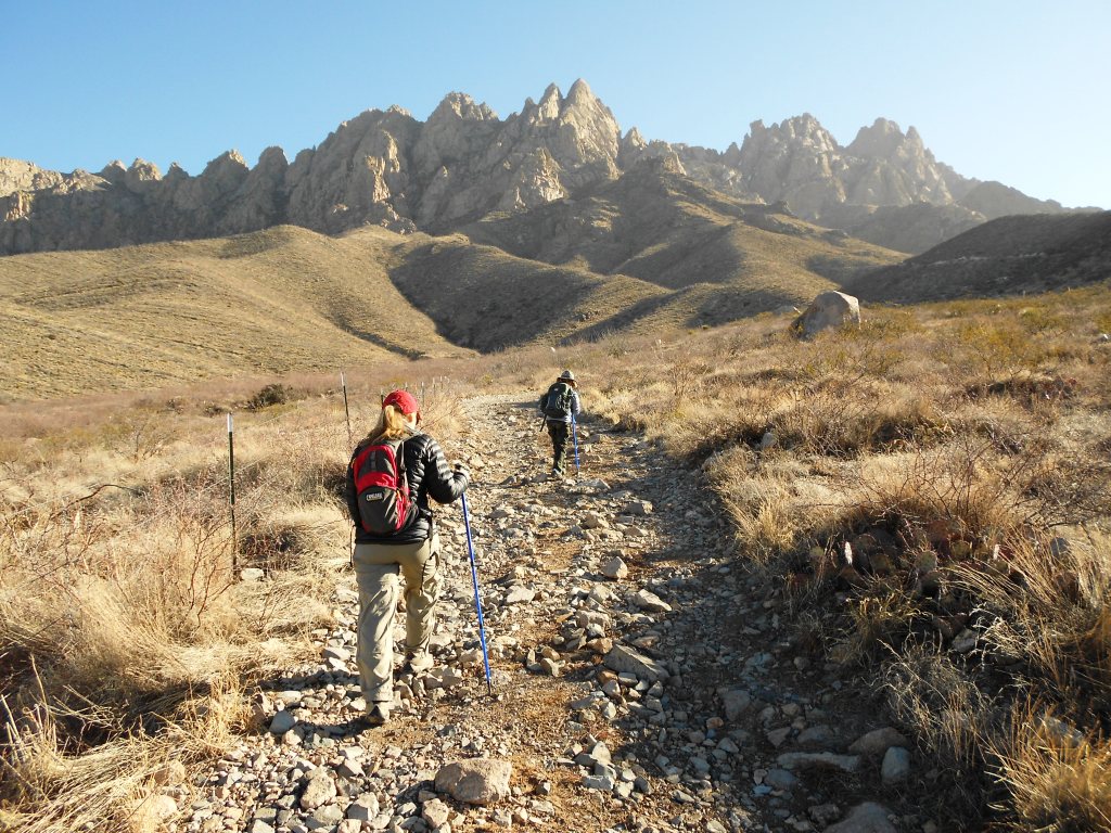
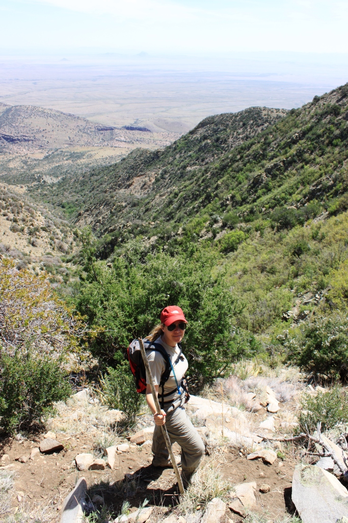
The first leg of our ride took us steeply up the side of Contrabando Peak, a series of high volcanic mountaintops.  The route appeared to follow the makings of a trail, consisting primarily of large, blackish-red pumice stones, with ocotillos seemingly growing next to our route on purpose.  My brush cloth jacket shed the needles without issue, though Monica, still wearing her thin down jacket from the chilly morning, tore a hole in her shell, forcing her to pack it up for the remainder of the trip.  My jacket would become my best friend later in the day after some nail-biting descents through the middle of several ocotillos.  A pair of chaps would have been nice.  During our ascent, several times we would sight the only large animals we would see during our entire visit, two separate groups of Javelina, all in a hurry to clear the area once we made ourselves known to them.  A larger group continued uphill while a pair of large Javelina moved off to our far right.  After hitting two high points along the crest, we began to descend down the high, open ground to the northeast.  Alex followed Armando along the route, and remained apprehensive about commanding her horse with her reins, which would not pose an issue until later, and her horse blissfully followed his (we teased Alex about her horse earlier for having its tongue hanging out the side of its mouth).  At several points along our route that had the appearance of a dead end, Armando would kid us about this, pretending to be indecisive but eventually charging down a slope that was cleverly hidden by the precipice next to him.  Later in the day he would do this at places where we had a clear view of our options, only to begin descending an unimaginable route.  After an hour, we reached the northern extent of the high mesa we traveled all morning.  In the distance to the north was a wide expanse of badlands of multiple colors, cut by a large dry river bed.  In the middle of this network was a small red cone-shaped hill top, with a larger gray hill to its rear.  This would be our destination for lunch.  As we came to the edge of a large gully that continued steeply down the mountainside eventually meeting the river bed, Armando asked us to hold in place while he scouted a route down.  Alex’s horse, confused by this, was intent on following Armando, and Alex’s commands with the reins did little to dissuade him.  Instead, he began following, then backing up, creating enough confusion to frighten Alex and force Armando and myself to move to her position.  Armando was obviously frustrated by my attempts to coach Alex and my eventual dismounting – something he may have forgotten to instruct us not to do at the beginning, and was now realizing his error.  Alex eventually collected her self and we abandoned our attempt to descend at that location.  We continued to move further east along the ridgeline, where at another saddle in the crest Armando felt that he had identified another route.  Pulling me aside, we agreed that we would attempt it, but he would lead Alex’s horse down the steep slope.  I trailed everyone else, with Derrick and his mount ahead of me.  Immediately after a few steps the lead horse was vertically below the next.  Derrick started his move, and I watched his horse slide three to four feet with every step.  The horses seemed nervous – up to this point I assumed that no matter what, my horse would follow through instinct.  But the rocks were large, it was steep, and there was no trail.  Our aim was to continue downhill towards the river bed far below, nothing more.  As my horse hesitated and began to travel in a different direction, it struck me that I would have to select every step of his route.  With complete disregard for my instructions, he became so confused he rode through the middle of an ocotillo.  Finally, we exited the open face of the slope into a more defined gulch and easily followed each other to the riverbed.  Along the way, a mule deer skullcap with antlers lay off the side of our newly established trail, and numerous pieces of blue stone, presumably copper residue, littered the trail.  Armando did not feel comfortable allowing us to take these with us, citing that it may or may not be in violation of state land restrictions.  I would make a mental note of these as we continued to the river bed.

Descending ridgeline, with dry river basin in distance.
Finally, in the riverbed, the horses acted as if a huge burden had been lifted and took off at a friendly trot.  During the excitement of the descent, or perhaps the galloping down the riverbed, my pocketknife freed itself from my left pants pocket.  After lunch Armando would insist we go back to find it, but I convinced him to continue.  We traveled up the riverbed, which was a combination of sand and yellow slate with 30 foot high walls, until we reached a series of steps near the red and gray hill.  There, on a stone bench, Armando prepared lunch while the horses fed on grasses growing alongside the base of the cliffs.  After a lunch of cold baked chicken, vegetables and cold cuts, Armando playfully teased Alex with a sleeve of Oreos, and we packed up and continued across the basin.  After riding another ½ mile up the river bed, we watered the horses at a small pond left by the rains of the previous weeks.  November and December was the first period the entire year where this part of the country received a nominal amount of rainfall.  Much of the surrounding area, including the Davis Mountains and around Alpine, Texas, were ravaged by the summer’s wildfires.  After watering the horses, we continued until we reached an old ruin made of yellow stone, which Armando referred to as “Casa Grande”, and claimed it was the remnant of an early 20th century ranch.  Half of all historic dwellings across the southwest are referred to as “Casa Grande”.  True or false, I placed little credence in his explanation.  Upon departing Casa Grande, we rode back to the southeast in the general direction of the mesa we descended before lunch.  From this perspective we were able to get a good view of the slope we descended earlier, with Derrick and I remarking proudly at the difficulty of the experience.  As humans in a modern, settled society, we often convince ourselves that no matter the circumstances, nothing bad will happen.  Belief systems and organizations encourage this assumption in a multitude of ways.  Financially millions of people find themselves in dire straits because they believe that if banks and credit companies didn’t think they could manage their finances, they wouldn’t extend them a line of credit.  Many young people find themselves seriously injured or killed in automobile accidents because they believe that despite drinking and driving at excessive speeds, the car’s safety systems and other driver’s defensiveness will prevent them from harm. “It can’t happen to me.”  The reality is there is never a guarantee that things will work out favorably for you, more so if you put your fate in someone else’s hands, and occasionally you experience that realization.  This realization could be something simple, as it was in the case of the descent on the horses, where we discovered that we would have to figure it out, and ended without incident, or more complicated, like the death of someone close or the complete loss of financial security.  And though a fleeting moment, that realization during this ride made the entire day worthwhile.  It pushed us out of normal level of comfort and security and forced us to act.  Could have something bad happened?  Unlikely – Armando was very conservative, not reckless in his attitude and approach to the ride.  But I appreciate the fact that he recognized our limits and pushed us as far as he could in a safe manner so we could have a remarkable experience.

Mounts during lunch.

Route-finding in the badlands.
 Armando led us to several more precipices, climbing up spurs in the mud hills to a dead end, and then dashing down the steep incline into the gully below.  Eventually, we began our climb back up to the mesa, with the afternoon sun blazing into our faces; we began to feel a bit fatigued.  With sore legs and aching backs, we steadily climbed up and over the crest, picking up a more defined trail which we followed back to the river.  Once the horses were back in the corral, we settled with Armando, said our goodbyes, and departed for the house.

Riding south across mesa, heading to stable.

Looking back at ridge line descent.  The saddle second from the left.

Derrick and Alex in the Kitchen.
Once back at the house, we prepared dinner and turned in earlier.  The next morning we would visit Big Bend National Park to do a driving tour and two hikes.  The wind picked up and the temperature dropped quickly, making it less desirable to sit out on the porch.  No fire pit, but a large firewood pile on the other end of the porch.  My assumption is Kaci Fullwood has a wood stove in her room, but not sure.  All the rooms have an electric and a kerosene heater.  At night we turn off the kerosene heater.   The bathroom has a small portable electric heater, which we leave on through the night.  At night the house is silent, thanks to the thick slab walls, save the old windows.  One of our bedroom windows squeaks on its hinge, making a noise similar to Alex speaking the word “Mom” over and over.  The second night I am more aware of it (it kept Monica up the first night) and we stack books, clothes, anything we can kind to stop the noise, but it manages to persist.  We take the large wooden block by the door, there as a doorstop, and lean against the door to prevent it from swinging open in the night, like a scene from the movie “Paranormal Activity”.  Otherwise, we sleep peacefully.  I awake early to make breakfast, part of the deal I had to strike with Monica in order to bargain for an early start each morning.  It’s much cooler today – not even forty degrees out.  For the remainder of the day we don’t see the temperature climb out of the 30s.
 
Santa Elena Canyon.
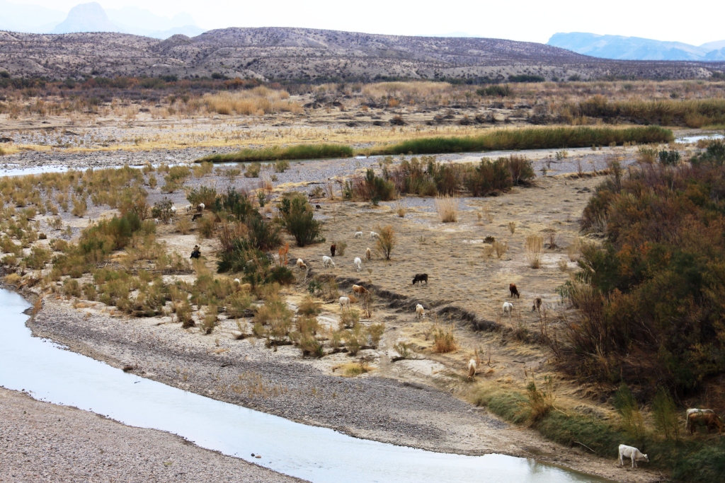
We entered the park a few miles east of Study Butte, and immediately turn south on Maverick Road, and head the fourteen miles to Santa Elena Canyon.  Maverick Road is gravel, but well-graded, so we move quickly.  After a couple of stops along the way, we reach the mouth of Santa Elena Canyon, which during our approach is a massive fissure in the long stone wall we can observe from our house in Terlingua.  The canyon begins near Lajitas and is one of the major highlights for rafting trips down the Rio Grande.  We park and cross the massive confluence of Terlingua Creek, which is dry from the drought.  On the opposite shore, the sheer walls of Santa Elena Canyon abruptly end and allow river banks and a flood plain to exist as the massive walls continue further back from the water line.  Above the beach in the grassy areas spotted with paloverde trees are two vaqueros with a small herd of cattle.  I’m not sure how far they are from home, but I imagine there are some small Mexican villages a few miles further downstream.  We take the short one-mile hike upriver until the walls close in and eliminate any shoreline on our side of the river.  Not a unique terrain feature, but remarkable nonetheless – here at the brink of a unique frontier, along the border, virtually unchanged since the days of Pancho Villa and Santa Anna, and as wild as when it was first occupied by native Americans thousands of years before.  The vaqueros seem unaware to how remarkable their circumstances are, their lives appearing as simple and pure as a work of art; though many of us imagine a life of simplicity, not fully realizing that those we long to be and the places where we desire to live are only true in the hearts and minds of those actually living them.  To believe that one can evolve from one world to another so easily and to experience what they regard as real is foolhardy.  Our lives develop in a way that does not permit this.  One can change their lifestyle and their home, but they cannot change who they are and how they came to be who they are.  This in itself prevents anyone from truly experiencing life through another’s eyes.  So, as is such, we look upon these romantic and simple scenes, and can grow no more closer to them, forcing us to admire them from afar, like a sculpture or fine painting.  It brings a feeling of grace and then disappears when the moment passes.  To admire and relish those moments is understandable; to attempt to alter your life to emulate this brings no one closer to what is real for the people living it.  You can identify this tendency in other parts of our lives – the rustic park lodge, the nostalgic coffee shop, the western steak house; the refurbished downtowns of historic areas, with their quaint boutiques and restaurants; it sometimes comes close, but never truly captures the realism of those simple times gone by, because they cannot.  Their employees leave work and don’t return to a humble prairie house with chickens alongside a river in the forest, but rather they return to their apartment or home, link up with friends or family, and go out to eat or see a movie.  It’s a novelty, nothing more.   This is why people buy weekend places in the mountains, why they buy small farms in rural communities, large ranches on prime real estate in the most picturesque areas.  They all seek the same thing – to find themselves in the middle of a work of art, feeling that moment of grace for as long as they can.  And they can do it without the risk of disease, crime, and other dangers of the period or society which they wish to emulate.  My eight-hour horseback ride is half as long as many people rode on a daily basis in the 19th century.  I would argue in those simpler circumstances, daily decisions are less complex, there’s less gray area in matters at hand, but they are no less consequential; and further, there is much less a degree of security when it comes to physical security, relationships and financial security.  When we contemplate a life that we identify as easier, nostalgic, we fail to realize that there are people born into those lives who dream of something else as well.  I imagine in the 19th century pioneer families did much of what they did out of necessity, rather than dreaming of a utopia or bohemian society.  Their existence was simply driven by wealth, survival, or independence, no different from today, or the future for that matter.  Country living might sound blissful, but not when you have to sleep with one eye open and worry if your children will live long enough to see their 18th birthday.  Notwithstanding, how we live in our daily lives at this moment characterizes our era and provides our identity in history – iPhones, Global War on Terror, rise of Islamic states, technology in our daily lives.  In summary, the preceding explanation can be simply defined by the common axiom, “beauty is in the eye of the beholder”.

Vaqueros and cattle at mouth of Santa Elena Canyon.
The trail is popular for such an isolated park, and I notice a group of hikers that look European, but not sure.  With them appears to be some sort of guide, carrying a backpack large enough to support someone on a two-week backpacking trip (for a 1.5 mile hike) and is constantly lecturing to them as a group.  Most of his gear and clothing looks incredibly ragged, leaving me wondering his history (and why anyone would need to hire a guide for a day hike).  It is cold out.  It’s windy, and the temperature can’t be more than the mid-thirties.  There are a lot of clouds and the Chiso Mountains to the northwest, our final destination for the day, are shrouded in fog.  We continue our drive along the river towards Castolon, and we pull over to look at what Monica believes is a turtle crossing the road.  It ends up being half-correct; it is definitely a turtle, but in skeleton form.  We pick up the shell expecting to see an angry face, but rather are looking into two black hollow eye sockets and turtle is as light as a feather.  We arrive in Castolon, a small visitor center and way station in the park, with a few historical buildings framed by Cerro Castellan to the north.  As we continue our drive north along the road to Santa Elena Junction, we begin looking for a place to stop and make lunch.  The wind and temperature is much worse now, and we pull off at Mule Ears Peak Overlook, but there are several other cars there and it does not afford the privacy we’re looking for.  We continue north, then make a left onto the road leading to Burro Mesa Pouroff Overlook, and drive to the trailhead for the Pouroff, a narrow desert gulch which ends with a dry waterfall.  It’s too cool outside and the wind is unbearable, so we fold down the backseats and make an area large enough for the four of us to gather and boil water for our soup.  Frustrating at first, the set-up is quite comfortable and provides a feeling of security from the outside elements.  After 30 minutes, we clean up and continue our drive towards the Chisos, but the weather seems to get worse as we get closer.  As we head east from Santa Elena Junction, a border patrol Jeep sits at the intersection, probably as a deterrent than ever likely to capture someone traveling illegally north.  The drive towards Basin Junction is dreary – a dark grey sky and with the mountains still shrouded in fog, not much to look at.  Past Basin Junction, we continue uphill for the final six miles to Chisos Basin, a high mountain plateau surrounded by the peaks of the Chisos.  Halfway up, rime ice encases all the trees and grasses within arms reach of the road, and we cannot see any further.  At the top, it’s evident by the temperature (28 degrees) and the visibility that we will not be doing our five-mile hike to the Window.  Tired of the bad weather and driving, we begin to head back to Terlingua.

Castolon outbuilding with Cerro Castellan in background.

The Chisos masked by clouds.

Dead turtle.

Derrick and Monica during lunch at the Pouroff.
About 2:30 p.m., about halfway back I announce that I want to hike into the basin we rode through the day before and retrieve the mule deer antlers, the copper stones, and attempt to locate my knife.  Derrick quickly announces that he’ll go as well.  For the rest of the drive I mull over a course of action.  In Study Butte, Derrick asleep, we stop at Many Stones, a rock shop with a rebel flag flying proudly out front.  The shop, like many rock shops, has an outdoor area as well.  Both areas are well-organized, and I compliment the proprietor, who is wearing black framed glasses, has a gray mustache, pony tail and a bandana around his forehead to mask his hair loss.  A wood stove in his living quarters just off the showroom floor heats the store and leaves us smelling like wood smoke.  Alex purchases a chunk of malachite and a small emerald-colored pendant and we drive back to the house, Derrick is still asleep.  After a few minutes, Derrick and I prepare for our hike, and depart the house at 3:25 p.m.  It gets dark in about 2-2 ½ hours, so our plan is simple:  drive down the Farm to Market Road past Contrabando Peak, to the Rio Bravo movie set, and walk in along the dry riverbed until we recognize the ridgeline and gully we descended the day prior.  It’s still cold, which I reason is good, because we need to move fast in order to reach our destination and return before dark.  After a few minutes it becomes evident that from this route everything is unfamiliar.  We try to avoid the temptation to climb to higher ground for vantage points since it will add more time to our ingress.  Eventually we come across a marked trail, the West Contrabando Trail, and begin to follow it.  Eventually it crosses to the north side of the river bed and moves further and further north, to the point we decide to head south and descend back to the river bed.  For over 1 ½ hours none of the terrain features we recognize come into view.  Finally, we make out the ridge crest we descended from the mesa and convince ourselves that the antlers are in one of two gullies we are looking at.  We debate over where we entered the riverbed on horseback to try to pinpoint our route and find evidence of our tracks for confirmation of the location.  We move up one gully, and then climb out on some high ground to make a decision.  We decide that I will continue up the gully to our front and Derrick will move over the spur to the gully to east to look.  As soon as Derrick moves out of view, I took a misstep and laid myself out facedown on the pumice-covered ground.  Though it is in the high 30s, I felt sweat running down my face.  We were already 30 minutes past my original “turn back” time.  As I moved up the center of the gully, I recognized the broken ground left by our hoof prints, and glancing in the ditch to my left, there lay the elk antlers.  I yell to Derrick that I had found them, but receive no answer.  I yell again, and Derrick answers back.  I grab several of the copper-laden rocks along the trail, and begin my move downhill to link-up with Derrick.  Derrick emerges from the east, holding a single antler in his hand, a lucky find.  Thrilled by our finds, we conspire to continue to look for the missing knife, but after some initial difficulty identifying yesterday’s route into the river bed, we cut our losses and begin our walk out.  We decide to stick to the river bed, pick up the trail for speed, then dead-reckon over the hills back to the car.  The route is not easy, but we return in about 75 minutes in the dark.

We return to the house and face Monica’s frustration for our disappearance, then begin to make dinner.  Derrick and I go out to start the gas grill in the dark, and find evidence that our hostess has been by the house – the propane tank is missing.  We find two of them along the wall of the house nearby, and hook one up, but are unable to get gas flowing, so we reluctantly pan-fry our salmon fillets.  Tired from two long days outside, we turn in and resort to reading until I fall asleep.  I’m halfway through “The Crossing” by Cormac McCarthy, reminiscent of the borderland frontier we spent the week exploring.

The next morning we depart without making breakfast, instead stopping by the Ghost Town Cafe, which takes only cash and we have $30 between us, so we decide to wait until we reach Presidio, Texas 65 miles away and 50 miles upriver.  After stopping at the Rio Bravo movie set and several other overlooks along what is probably the most magnificent stretch of the Rio Grande, with its high desert mountains dusted with snow and emerald water, we reach the forgotten town of Presidio, which in many ways fits the romantic description mentioned earlier.  Like most border towns, the population is nearly all Hispanic, and the town is stretched out on the open desert landscape, many of the structures abandoned or near abandonment.  Aside from the Mexican influence, this could be one of hundreds of western towns I have passed through between Montana and California.  We eat at the El Patio Restaurant, a simple diner on the main street in town.  It is Christmas Eve and though we are in the brush stroke of New Mexican Catholic influence that covers parts of Arizona, New Mexico and West Texas, there are only a few simple decorations in the restaurant and in the town period.  The food is practical, but forgettable, and after finishing our meals and receiving stares and glares we exit and hit the road north to Marfa.

Coyote along Rio Grande east of Lajitas.

Looking into Mexico across Rio Grande.  Note horse in center of photo, below bluff.

The Rio Grande.
There’s a lot of snow on the roads, but it does little to slow us down, except for the occasional cautious motorist that appears in front of us.  The landscape through here is monotonous, but still beautiful.  Wide open plains with a few accenting hills in the distant, covered with snow.  In one open valley we see a group of camels traveling.  We passed through Marfa, and then past the border patrol Aerostat blimp, which is grounded due to the weather, then pass through Valentine, stopping to photograph an abandoned home ready to collapse with vivid aquamarine door length shutters.  The wide open valley runs to our west for miles, eventually broken by the Sierra Vieja, rarely visible due to the cloud cover and low-lying fog created by the snow flurries, unbroken but for the occasional defunct windmill and water tank.  Valentine, for the most part a ghost town at the southern end of a pecan orchard, is perfect in its current state.  To do anything to it, whether it be to open a gallery or coffee shop on Main Street for the occasional traveler, would forbid us and everyone else from experiencing that moment of grace we endlessly seek.

House in Valentine, Texas.